Ahmed Kamel – Egypt Daily News
A powerful and unusually organized storm system is forecast to sweep across the Middle East this week, raising concerns about severe weather impacts in a region already strained by ongoing military conflict involving Iran, Israel, and several Gulf states.
Meteorologists warn that while storms are not uncommon in the region, the scale and intensity of this system are considered highly anomalous. The storm is expected to bring a combination of heavy rainfall, severe thunderstorms, dust storms known as haboobs, and even the possibility of brief tornadoes across multiple countries.
The system is forecast to begin affecting Israel and Lebanon on Wednesday, with scattered showers and thunderstorms developing during the day. However, conditions are expected to deteriorate significantly by Thursday as the storm strengthens and expands geographically.
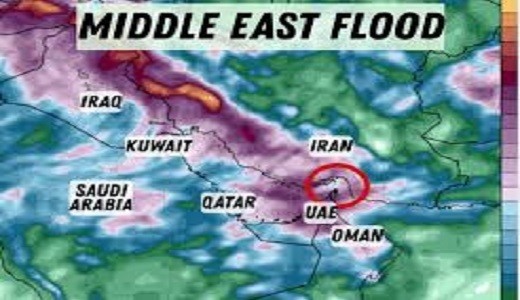
By then, the most severe impacts are likely to stretch from Syria southward across the Arabian Peninsula, affecting countries including Saudi Arabia, Qatar, Kuwait, the United Arab Emirates, and parts of Iran. The peak of the storm is expected between Thursday and Friday.
Forecasters highlight the risk of severe thunderstorms capable of producing damaging winds exceeding 60 miles per hour, large hail, and isolated tornadoes. Flash flooding is another major concern, with some areas potentially receiving more than one inch of rainfall in a short period—an amount that could overwhelm urban infrastructure in typically arid environments.
Cities such as Dubai and Abu Dhabi are particularly vulnerable. According to data from the World Meteorological Organization, Dubai receives an average of just over three inches of rainfall annually, meaning even a single storm delivering a significant portion of that total could lead to widespread disruption and localized flooding.
In addition to heavy rainfall, large dust storms are expected to sweep across desert regions, reducing visibility and posing hazards to transportation and infrastructure. These haboobs, driven by strong downdrafts from thunderstorms, can carry dense walls of dust across vast distances.
Parts of Iran may also experience varied weather conditions due to its diverse topography, with mountainous regions potentially seeing snowfall as the system moves through.
The storm is expected to gradually clear the region by Saturday, but its impacts could linger, particularly in flood-prone areas.
The severe weather threat comes against the backdrop of escalating military activity in the region. Since late February, Iran has been the site of ongoing strikes, including coordinated operations by the United States and Israel targeting military and government facilities, as well as retaliatory actions by Tehran.
Analysts warn that the convergence of extreme weather and active conflict zones could complicate military operations, disrupt logistics, and increase risks for civilians across multiple countries.
